
Malmbäck topographic map
Interactive map
Click on the map to display elevation.
About this map
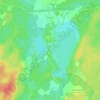
Name: Malmbäck topographic map, elevation, terrain.
Average elevation: 157 m
Minimum elevation: 137 m
Maximum elevation: 186 m
Other topographic maps
Click on a map to view its topography, its elevation and its terrain.
Växjö
Sweden > Kronoberg County > Växjö
Växjö, Växjö kommun, Kronoberg County, Region Götaland, 351 04, Sweden
Average elevation: 174 m
Hultaklint
Sweden > Kronoberg County > Växjö
Hultaklint, Lädja Klövaliden, Östenhaga, Växjö, Växjö kommun, Kronoberg County, Region Götaland, 360 30, Sweden
Average elevation: 244 m
Tagel
Sweden > Kronoberg County > Tagel
Tagel, Alvesta kommun, Kronoberg County, Region Götaland, Sweden
Average elevation: 197 m
Sävsjöström
Sweden > Kronoberg County > Sävsjöström
Sävsjöström, Uppvidinge kommun, Kronoberg County, Region Götaland, Sweden
Average elevation: 232 m
Saxnäs
Sweden > Kronoberg County > Saxnäs
Saxnäs, Ljungby kommun, Kronoberg County, Region Götaland, Sweden
Average elevation: 161 m