
Marquam Nature Park topographic map
Interactive map
Click on the map to display elevation.
About this map
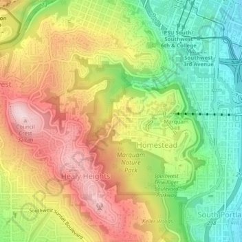
Name: Marquam Nature Park topographic map, elevation, terrain.
Average elevation: 163 m
Minimum elevation: 5 m
Maximum elevation: 332 m
Other topographic maps
Click on a map to view its topography, its elevation and its terrain.
Gabriel Park
United States > Oregon > Portland
Gabriel Park, Multnomah, Portland, Metro, Multnomah County, Oregon, United States
Average elevation: 130 m
George Himes Park
United States > Oregon > Portland
George Himes Park, Hillsdale, Portland, Multnomah County, Oregon, United States
Average elevation: 108 m
Mount Tabor
United States > Oregon > Portland
Mount Tabor, Portland, Multnomah County, Oregon, 97215, United States
Average elevation: 86 m