
Watauga Lake topographic map
Interactive map
Click on the map to display elevation.
About this map
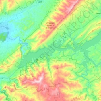
Name: Watauga Lake topographic map, elevation, terrain.
Location: Watauga Lake, Carter County, Tennessee, 37640, United States (36.27698 -82.13142 36.38169 -81.92823)
Average elevation: 755 m
Minimum elevation: 469 m
Maximum elevation: 1,298 m
According to the 2004 TVA River and Reservoir Operations Study, Watauga Lake is approximately 16.3 mi (26.2 km) long, with 104.9 mi (168.8 km) of shoreline. At the TVA summertime water level target "full pool", the lake surface covers 6,430 acres (26 km²) and the estimated depth of Watauga Lake is 265 feet (81 m) at the dam. At full pool, Watauga's elevation is the highest of all TVA lakes at 1,959 feet (597 m) above sea level.
Other topographic maps
Click on a map to view its topography, its elevation and its terrain.
Elizabethton
United States > Tennessee > Carter County > Elizabethton > Elizabethton
Elizabethton, Carter County, Tennessee, 37643, United States
Average elevation: 527 m
Roan Mountain
United States > Tennessee > Carter County
Roan Mountain, Carter County, East Tennessee, Tennessee, United States
Average elevation: 1,418 m
Pine Crest
United States > Tennessee > Carter County
Pine Crest, Carter County, East Tennessee, Tennessee, United States
Average elevation: 515 m
Tolley Town
United States > Tennessee > Carter County
Tolley Town, Carter County, East Tennessee, Tennessee, United States
Average elevation: 896 m
Winner
United States > Tennessee > Carter County
Winner, Carter County, East Tennessee, Tennessee, United States
Average elevation: 614 m
Roan Mountain State Park
United States > Tennessee > Carter County > Roan Mountain
Roan Mountain State Park, Roan Mountain, Carter County, East Tennessee, Tennessee, United States
Average elevation: 988 m
Central
United States > Tennessee > Carter County
Central, Carter County, East Tennessee, Tennessee, United States
Average elevation: 489 m
Elk Mills
United States > Tennessee > Carter County
Elk Mills, Carter County, Tennessee, United States
Average elevation: 749 m
Roan Mountain
United States > Tennessee > Carter County
Roan Mountain, Carter County, East Tennessee, Tennessee, 37687, United States
Average elevation: 926 m
Dogtown
United States > Tennessee > Carter County
Dogtown, Carter County, Tennessee, United States
Average elevation: 617 m
Jane Bald
United States > Tennessee > Carter County
Jane Bald, Carter County, East Tennessee, Tennessee, United States
Average elevation: 1,573 m
Watauga
United States > Tennessee > Carter County
Watauga, Carter County, East Tennessee, Tennessee, United States
Average elevation: 465 m
Hunter
United States > Tennessee > Carter County
Hunter, Carter County, Tennessee, United States
Average elevation: 706 m
Milligan
United States > Tennessee > Carter County > Elizabethton > Milligan
Milligan, Elizabethton, Carter County, Tennessee, 37605, United States
Average elevation: 508 m
Hampton
United States > Tennessee > Carter County
Hampton, Carter County, East Tennessee, Tennessee, 37658, United States
Average elevation: 674 m
Valley Park
United States > Tennessee > Carter County > Elizabethton > Valley Park
Valley Park, Elizabethton, Carter County, Tennessee, 37643, United States
Average elevation: 515 m
Elizabethton
United States > Tennessee > Carter County
Elizabethton, Carter County, East Tennessee, Tennessee, United States
Average elevation: 567 m