
Lewis County topographic map
Interactive map
Click on the map to display elevation.
About this map
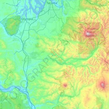
Name: Lewis County topographic map, elevation, terrain.
Location: Lewis County, Washington, United States (46.38127 -123.37090 46.79445 -121.35268)
Average elevation: 558 m
Minimum elevation: -3 m
Maximum elevation: 4,320 m
Other topographic maps
Click on a map to view its topography, its elevation and its terrain.
Chehalis
United States > Washington > Lewis County
Chehalis, Lewis County, Washington, United States, Stan Hedwall Park
Average elevation: 67 m
Chehalis
United States > Washington > Lewis County > Chehalis > Chehalis
Chehalis, Lewis County, Washington, United States
Average elevation: 85 m
Randle
United States > Washington > Lewis County > Randle
Randle, Lewis County, Washington, United States
Average elevation: 378 m