
Upper Falls topographic map
Interactive map
Click on the map to display elevation.
About this map
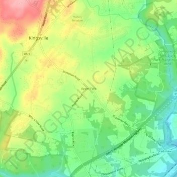
Name: Upper Falls topographic map, elevation, terrain.
Average elevation: 61 m
Minimum elevation: 6 m
Maximum elevation: 135 m
Other topographic maps
Click on a map to view its topography, its elevation and its terrain.
Fork
United States > Maryland > Baltimore County > Kingsville
Fork, Kingsville, Baltimore County, Maryland, 21051, United States
Average elevation: 120 m
Kingsville
United States > Maryland > Baltimore County > Kingsville
Kingsville, Baltimore County, Maryland, 21087, United States
Average elevation: 85 m