
Osmaniye topographic map
Interactive map
Click on the map to display elevation.
About this map
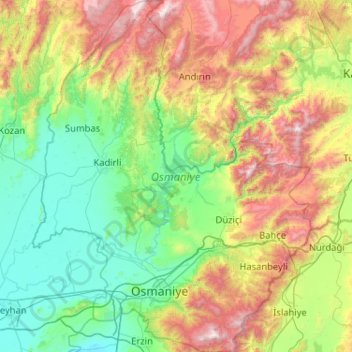
Name: Osmaniye topographic map, elevation, terrain.
Location: Osmaniye, Mediterranean Region, Turkey (36.92973 35.87645 37.74978 36.70093)
Average elevation: 630 m
Minimum elevation: 1 m
Maximum elevation: 2,269 m
Osmaniye (pronounced ) is a city in the Çukurova region of Turkey, the capital of Osmaniye Province. Area 3,767 km². Population of Osmaniye city: 219,339. Osmaniye Province: 512,804 (2014). Osmaniye is at an elevation of 125 meters (410.1 feet).