
Cumberland County topographic map
Interactive map
Click on the map to display elevation.
About this map
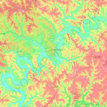
Name: Cumberland County topographic map, elevation, terrain.
Location: Cumberland County, Kentucky, United States of America (36.61853 -85.60121 36.93842 -85.21472)
Average elevation: 237 m
Minimum elevation: 157 m
Maximum elevation: 344 m
Other topographic maps
Click on a map to view its topography, its elevation and its terrain.
Warfield
United States of America > Kentucky > Warfield
Warfield, Martin County, Kentucky, 41267, United States of America
Average elevation: 259 m
Williamstown
United States of America > Kentucky > Williamstown
Williamstown, Grant County, Kentucky, 41097, United States of America
Average elevation: 262 m
Paducah
United States of America > Kentucky > Paducah
Paducah, McCracken County, Kentucky, United States of America
Average elevation: 108 m
Monroe County
United States of America > Kentucky
Monroe County, Kentucky, United States of America
Average elevation: 250 m
Yosemite
United States of America > Kentucky > Yosemite
Yosemite, Casey County, Kentucky, 42541, United States of America
Average elevation: 285 m