
Hamilton topographic map
Interactive map
Click on the map to display elevation.
About this map
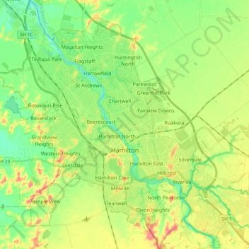
Name: Hamilton topographic map, elevation, terrain.
Location: Hamilton, Waikato, New Zealand (-37.84604 175.18430 -37.69933 175.34488)
Average elevation: 42 m
Minimum elevation: 11 m
Maximum elevation: 89 m
Other topographic maps
Click on a map to view its topography, its elevation and its terrain.
Scotsman Valley
New Zealand > Waikato > Waikato District
Scotsman Valley, Waikato District, Waikato, New Zealand
Average elevation: 108 m
Wentworth Valley
New Zealand > Waikato > Thames-Coromandel District
Wentworth Valley, Thames-Coromandel District, Waikato, New Zealand
Average elevation: 114 m
Eureka
New Zealand > Waikato > Waikato District
Eureka, Waikato District, Waikato, 3287, New Zealand
Average elevation: 49 m
Wyuna Bay
New Zealand > Waikato > Coromandel > Wyuna Bay
Wyuna Bay, Coromandel, Thames Coromandel District, Waikato, 3543, New Zealand
Average elevation: 12 m