
Shiraz topographic map
Interactive map
Click on the map to display elevation.
About this map
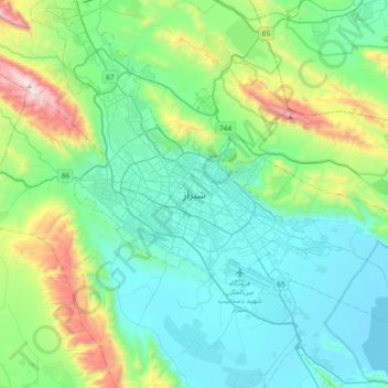
Name: Shiraz topographic map, elevation, terrain.
Average elevation: 1,754 m
Minimum elevation: 1,460 m
Maximum elevation: 2,873 m
Other topographic maps
Click on a map to view its topography, its elevation and its terrain.
Zand
Iran > Fars Province > Shiraz County > Shiraz
Zand, zone 2, Shiraz, Shiraz Central District, Shiraz County, Fars Province, Iran
Average elevation: 1,543 m
Seraj
Iran > Fars Province > Shiraz County > Shiraz
Seraj, zone 4, Shiraz, Shiraz Central District, Shiraz County, Fars Province, Iran
Average elevation: 1,552 m