
Gasabo topographic map
Interactive map
Click on the map to display elevation.
About this map
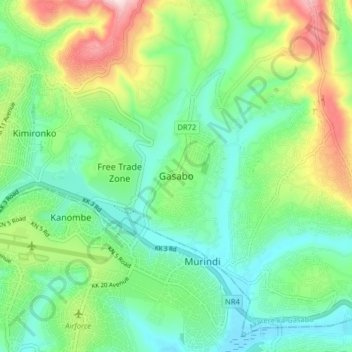
Name: Gasabo topographic map, elevation, terrain.
Location: Gasabo, Gasabo District, Kigali City, Rwanda (-1.99231 30.13048 -1.91231 30.21048)
Average elevation: 1,456 m
Minimum elevation: 1,337 m
Maximum elevation: 1,725 m
Other topographic maps
Click on a map to view its topography, its elevation and its terrain.
Bumbogo
Rwanda > Kigali City > Gasabo District
Bumbogo, Gasabo District, Kigali City, Rwanda
Average elevation: 1,644 m