
Orofino topographic map
Interactive map
Click on the map to display elevation.
About this map
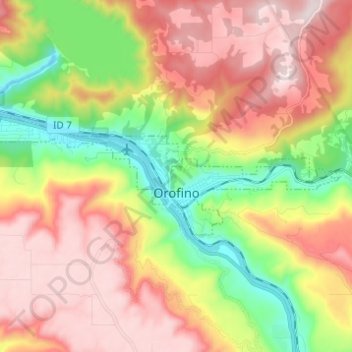
Name: Orofino topographic map, elevation, terrain.
Location: Orofino, Clearwater County, Idaho, 83544, United States (46.47097 -116.32122 46.49939 -116.19855)
Average elevation: 633 m
Minimum elevation: 293 m
Maximum elevation: 964 m
Due to the area’s relatively low elevation, the climate is ranked as among the hottest in the summer and the mildest in the winter throughout the entire state. The moderate winters are also influenced by the city’s northwestern location, which places it closer to the Pacific Ocean than many other parts of Idaho. Idaho’s all-time highest temperature of 118 °F or 47.8 °C was recorded at Orofino on July 28, 1934.
Other topographic maps
Click on a map to view its topography, its elevation and its terrain.
Weippe
United States > Idaho > Clearwater County
Weippe, Clearwater County, Idaho, 83553, United States
Average elevation: 926 m
Ahsahka
United States > Idaho > Clearwater County
Ahsahka, Clearwater County, Idaho, 83520, United States
Average elevation: 422 m
Elk River
United States > Idaho > Clearwater County
Elk River, Clearwater County, Idaho, 83827, United States
Average elevation: 907 m
Pierce
United States > Idaho > Clearwater County
Pierce, Clearwater County, Idaho, 83546, United States
Average elevation: 1,004 m
Orofino
United States > Idaho > Clearwater County > Orofino > Orofino
Orofino, Clearwater County, Idaho, 83544, United States
Average elevation: 627 m