
Palawan topographic map
Interactive map
Click on the map to display elevation.
About this map
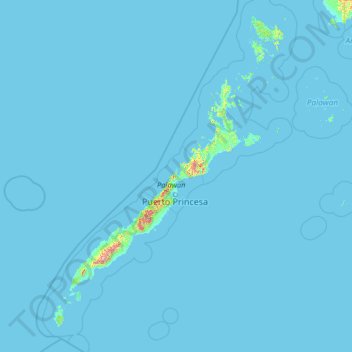
Name: Palawan topographic map, elevation, terrain.
Location: Palawan, Mimaropa, Philippines (7.44000 116.19000 12.56000 121.31000)
Average elevation: 8 m
Minimum elevation: -1 m
Maximum elevation: 1,912 m
Other topographic maps
Click on a map to view its topography, its elevation and its terrain.
Puerto Princesa
Philippines > Palawan > Puerto Princesa
Puerto Princesa, Palawan, Mimaropa, 5300, Philippines
Average elevation: 92 m
Pass Island
Philippines > Palawan > Busuanga
Pass Island, Busuanga, Palawan, Mimaropa, 5317, Philippines
Average elevation: 20 m
Cataban
Philippines > Palawan > Cataban
Cataban, Palawan, Mimaropa, Philippines
Average elevation: 79 m
Busuanga Island
Busuanga Island, Coron, Palawan, Mimaropa, 5316, Philippines
Average elevation: 33 m
Taraw Peak
Taraw Peak, Palawan, Mimaropa, 5313, Philippines
Average elevation: 57 m