
Mae Hong Son Province topographic map
Interactive map
Click on the map to display elevation.
About this map
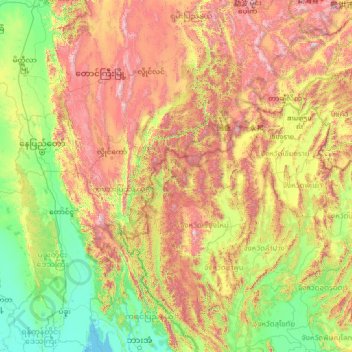
Name: Mae Hong Son Province topographic map, elevation, terrain.
Location: Mae Hong Son Province, Thailand (16.83275 95.64311 21.95275 100.76311)
Average elevation: 604 m
Minimum elevation: -1 m
Maximum elevation: 2,516 m
The Daen Lao Range, in the northernmost portion of the province, marks the northern boundary between Thailand and Burma, while the Dawna Range in the west serves as the boundary between Thailand and Burma. The Thanon Thongchai Range in the east of the province serves as the boundary between the provinces of Mae Hong Son and Chiang Mai. The highest point of the province is Doi Mae Ya (ยอดเขาแม่ยะ), in the Pai District in the province's northeast, at 2,005 metres (6,578 ft) elevation.
Other topographic maps
Click on a map to view its topography, its elevation and its terrain.
Ban Huai Pu
Thailand > Mae Hong Son Province > Ban Rai
Ban Huai Pu, Ban Rai, Mae Yuam, Mae Sariang, Mae Hong Son Province, 58110, Thailand
Average elevation: 249 m
Pai
Thailand > Mae Hong Son Province
Pai, Mae Hong Son Province, 58130, Thailand
Average elevation: 605 m
Ban Na Kao
Thailand > Mae Hong Son Province > Ban Na Kao
Ban Na Kao, Mae Hong Son Province, 58110, Thailand
Average elevation: 269 m