
Sint Eustatius topographic map
Interactive map
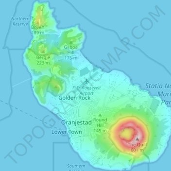
Click on the map to display elevation.
About this map
Name: Sint Eustatius topographic map, elevation, terrain.
Average elevation: 48 m
Minimum elevation: 0 m
Maximum elevation: 559 m
Sint Eustatius is 6 miles (10 km) long and up to 3 miles (5 km) wide. Topographically, the island is saddle-shaped, with the 602 meter-high dormant volcano Quill (Mount Mazinga), (from Dutch kuil, meaning 'pit'—originally referring to its crater) to the southeast and the smaller pair of Signal Hill/Little Mountain (or Bergje) and Boven Mountain to the northwest. The Quill crater is a popular tourist attraction on the island. The bulk of the island's population lives in the flat saddle between the two elevated areas, which forms the centre of the island.
Other topographic maps
Click on a map to view its topography, its elevation and its terrain.
Saint Johns
The Netherlands > Caribbean Netherlands > Saint Johns
Saint Johns, Caribbean Netherlands, Netherlands, The Netherlands
Average elevation: 153 m