
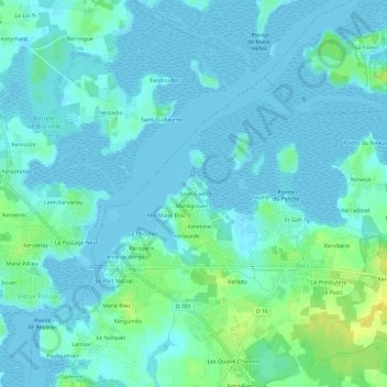
Saint-Cado topographic map
Interactive map
Click on the map to display elevation.
About this map
Name: Saint-Cado topographic map, elevation, terrain.
Average elevation: 5 m
Minimum elevation: -2 m
Maximum elevation: 22 m
Other topographic maps
Click on a map to view its topography, its elevation and its terrain.
Larmor
France > Bretagne > Morbihan > Pont Lorois
Larmor, Pont Lorois, Belz, Lorient, Morbihan, Bretagne, France métropolitaine, 56550, France
Average elevation: 7 m
Le Chochet
France > Bretagne > Morbihan > Pont Lorois > Le Chochet
Le Chochet, Pont Lorois, Belz, Lorient, Morbihan, Bretagne, France métropolitaine, 56550, France
Average elevation: 5 m
Les Quatre Chemins
France > Bretagne > Morbihan > Pont Lorois
Les Quatre Chemins, Pont Lorois, Belz, Lorient, Morbihan, Bretagne, France métropolitaine, 56550, France
Average elevation: 9 m
Kerlutu
France > Bretagne > Morbihan > Pont Lorois
Kerlutu, Pont Lorois, Belz, Lorient, Morbihan, Bretagne, France métropolitaine, 56550, France
Average elevation: 7 m