
Maarrat al-Nu'man topographic map
Interactive map
Click on the map to display elevation.
About this map
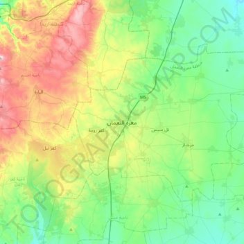
Name: Maarrat al-Nu'man topographic map, elevation, terrain.
Location: Maarrat al-Nu'man, Idlib, Syria (35.48708 36.51771 35.80708 36.83771)
Average elevation: 522 m
Minimum elevation: 338 m
Maximum elevation: 930 m
Other topographic maps
Click on a map to view its topography, its elevation and its terrain.
Khan Shaykhun
Syria > Idlib > Maarrat al-Nu'man
Khan Shaykhun, Maarrat al-Nu'man, Idlib, Syria
Average elevation: 374 m