
Prachuap Khiri Khan Province topographic map
Interactive map
Click on the map to display elevation.
About this map
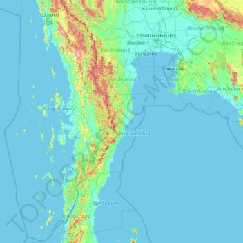
Name: Prachuap Khiri Khan Province topographic map, elevation, terrain.
Location: Prachuap Khiri Khan Province, Thailand (9.48327 97.18872 14.60327 102.30872)
Average elevation: 68 m
Minimum elevation: -3 m
Maximum elevation: 1,633 m
Prachuap Khiri Khan covers an area of 6,367 square kilometres (2,458 sq mi). The province is on the Kra Isthmus, the narrow land bridge connecting the Malay Peninsula with mainland Asia. The province has the narrowest part of Thailand, just 13 km (8.1 mi) from the Gulf of Thailand to the border with Myanmar in the Tenasserim Hills. Geographically, Prachuap Khiri Khan is a moderate plain with elevations varying from sea level to 1,200 m (3,900 ft). The maximum elevations are found in the northeastern and central west regions, which make up approximately 30 percent of the province.
Other topographic maps
Click on a map to view its topography, its elevation and its terrain.
Khao Thongchai ca. 84 m เขาธงชัย
Thailand > Prachuap Khiri Khan Province > Ban Thung Ruea Yao
Khao Thongchai ca. 84 m เขาธงชัย, Ban Thung Ruea Yao, Prachuap Khiri Khan Province, 77190, Thailand
Average elevation: 6 m