
Mike Lake topographic map
Interactive map
Click on the map to display elevation.
About this map
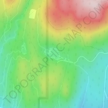
Name: Mike Lake topographic map, elevation, terrain.
Average elevation: 297 m
Minimum elevation: 147 m
Maximum elevation: 527 m
Other topographic maps
Click on a map to view its topography, its elevation and its terrain.
Maple Ridge
Canada > British Columbia > Maple Ridge
Maple Ridge, Metro Vancouver Regional District, British Columbia, V2X 6G2, Canada
Average elevation: 193 m
Maple Ridge
Canada > British Columbia > Maple Ridge
Maple Ridge, Metro Vancouver Regional District, British Columbia, V2X 6G2, Canada
Average elevation: 193 m