
Olofströms kommun topographic map
Interactive map
Click on the map to display elevation.
About this map
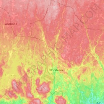
Name: Olofströms kommun topographic map, elevation, terrain.
Location: Olofströms kommun, Blekinge County, Region Götaland, Sweden (56.19048 14.39016 56.45999 14.74665)
Average elevation: 108 m
Minimum elevation: 11 m
Maximum elevation: 187 m
Other topographic maps
Click on a map to view its topography, its elevation and its terrain.
Lassabo
Sweden > Blekinge County > Lassabo
Lassabo, Sölvesborg, Blekinge County, Region Götaland, 29471, Sweden
Average elevation: 15 m