
Haut-Katanga topographic map
Interactive map
Click on the map to display elevation.
About this map
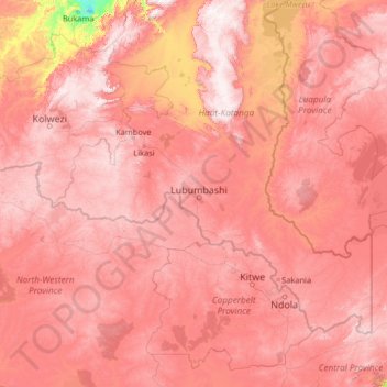
Name: Haut-Katanga topographic map, elevation, terrain.
Location: Haut-Katanga, Democratic Republic of the Congo (-14.16474 24.85319 -9.04474 29.97319)
Average elevation: 1,218 m
Minimum elevation: 570 m
Maximum elevation: 1,783 m
Other topographic maps
Click on a map to view its topography, its elevation and its terrain.
Munua
Democratic Republic of the Congo > Haut-Katanga > Ville de Lubumbashi
Munua, Annexe, Ville de Lubumbashi, Haut-Katanga, Democratic Republic of the Congo
Average elevation: 1,271 m
Quebec
Democratic Republic of the Congo > Haut-Katanga > Ville de Lubumbashi > Lubumbashi
Quebec, Salama, Lubumbashi, Ville de Lubumbashi, Haut-Katanga, Democratic Republic of the Congo
Average elevation: 1,219 m