
County Down topographic map
Interactive map
Click on the map to display elevation.
About this map
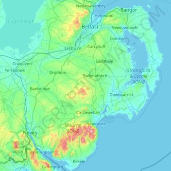
Name: County Down topographic map, elevation, terrain.
Location: County Down, Northern Ireland, United Kingdom (54.02289 -6.40037 54.69924 -5.42682)
Average elevation: 65 m
Minimum elevation: -3 m
Maximum elevation: 839 m
Other topographic maps
Click on a map to view its topography, its elevation and its terrain.
Newry
United Kingdom > Northern Ireland > County Down
Newry, County Down, Northern Ireland, United Kingdom
Average elevation: 73 m
Dundonald
United Kingdom > Northern Ireland > County Down
Dundonald, County Down, Ulster, Northern Ireland, BT16 1RH, United Kingdom
Average elevation: 80 m
Killough
United Kingdom > Northern Ireland > County Down
Killough, County Down, Ulster, Northern Ireland, BT30 7QQ, United Kingdom
Average elevation: 7 m
Ballynahinch
United Kingdom > Northern Ireland > County Down > Ballynahinch
Ballynahinch, County Down, Ulster, Northern Ireland, BT24 8DN, United Kingdom
Average elevation: 99 m
Lawrencetown
United Kingdom > Northern Ireland > County Down
Lawrencetown, County Down, Northern Ireland, BT63 6DU, United Kingdom
Average elevation: 72 m
Saintfield
United Kingdom > Northern Ireland > County Down
Saintfield, County Down, Ulster, Northern Ireland, BT24 7AA, United Kingdom
Average elevation: 87 m