
Paulding County topographic map
Interactive map
Click on the map to display elevation.
About this map
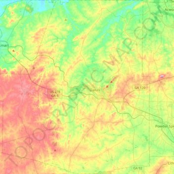
Name: Paulding County topographic map, elevation, terrain.
Location: Paulding County, Georgia, United States (33.77476 -85.05031 34.08261 -84.72324)
Average elevation: 311 m
Minimum elevation: 211 m
Maximum elevation: 452 m
The county is mainly located in the Piedmont region of the state, with a few mountains located in the county that exceed elevations of 1,000 ft. These mountains are considered to be part of the southernmost extensions of the Appalachian Mountains.
Other topographic maps
Click on a map to view its topography, its elevation and its terrain.
Hiram
United States > Georgia > Paulding County
Hiram, Paulding County, Georgia, United States
Average elevation: 306 m