
Vänern topographic map
Interactive map
Click on the map to display elevation.
About this map
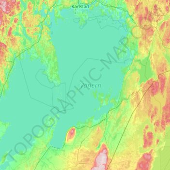
Name: Vänern topographic map, elevation, terrain.
Average elevation: 78 m
Minimum elevation: 40 m
Maximum elevation: 303 m
Other topographic maps
Click on a map to view its topography, its elevation and its terrain.
Åkershus
Sweden > Värmland County > Åkershus
Åkershus, Säffle kommun, Värmland County, Region Svealand, Sweden
Average elevation: 47 m