
Graham County topographic map
Interactive map
Click on the map to display elevation.
About this map
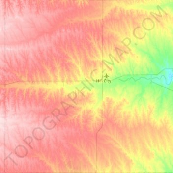
Name: Graham County topographic map, elevation, terrain.
Location: Graham County, Kansas, USA (39.13183 -100.16421 39.56749 -99.60192)
Average elevation: 720 m
Minimum elevation: 600 m
Maximum elevation: 813 m
Other topographic maps
Click on a map to view its topography, its elevation and its terrain.
Tallgrass Prairie National Preserve
Tallgrass Prairie National Preserve, Prairie Fire Loop, Chase County, Kansas, USA
Average elevation: 411 m
Milford Lake
Milford Lake, School Creek Road, Milford, Geary County, Kansas, 66514, USA
Average elevation: 371 m
Charles Lake
Charles Lake, 1600 Street, Allen County, Kansas, 66749, USA
Average elevation: 300 m
Independence
USA > Kansas > Independence
Independence, Montgomery County, Kansas, 67301, USA
Average elevation: 245 m