
Fremont County topographic map
Interactive map
Click on the map to display elevation.
About this map
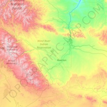
Name: Fremont County topographic map, elevation, terrain.
Location: Fremont County, Wyoming, United States of America (42.25957 -110.05364 44.00916 -107.49413)
Average elevation: 2,108 m
Minimum elevation: 1,230 m
Maximum elevation: 4,047 m
According to the US Census Bureau, the county has a total area of 9,266 square miles (24,000 km2), of which 9,184 square miles (23,790 km2) is land and 82 square miles (210 km2) (0.9%) is water. It is the second-largest county by area in Wyoming, as well as in the six Rocky Mountain States. Elevations and climate range from desert at Boysen State Park to glaciers at 13,804-foot (4,207 m) Gannett Peak, the highest point not only in Wyoming but in the three Central Rockies states of Wyoming, Idaho and Montana. The southern end of the county is traversed by the Oregon Trail and in the northwest corner lies Dubois, a gateway town for Yellowstone National Park and Grand Teton National Park. Although the county seat is Lander, the largest community is Riverton, home of Central Wyoming College and the economic hub of the region. A large portion of the western edge of the county follows the Continental Divide at the crest of the Wind River Range of the Rocky Mountains, known for its wilderness areas and home of the largest glaciers in the American Rocky Mountains.
Other topographic maps
Click on a map to view its topography, its elevation and its terrain.
Rawlins
United States of America > Wyoming > Rawlins
Rawlins, Carbon County, Wyoming, United States of America
Average elevation: 2,098 m
Sundance
United States of America > Wyoming > Sundance
Sundance, Crook County, Wyoming, 82709, United States of America
Average elevation: 1,507 m
Moose
United States of America > Wyoming > Moose
Moose, Teton County, Wyoming, United States of America
Average elevation: 2,007 m