
Gradac topographic map
Interactive map
Click on the map to display elevation.
About this map
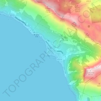
Name: Gradac topographic map, elevation, terrain.
Location: Gradac, Općina Gradac, 21330, Croatia (43.08645 17.32169 43.12645 17.36169)
Average elevation: 182 m
Minimum elevation: 0 m
Maximum elevation: 747 m
Under its present name, Gradac was mentioned for the first time in 1649. It was named after the stronghold that was situated on the elevation above the present-day church of St. Michael, and which was built probably during the Cretan War (1645–1669) as a defence against the Turks. According to the drawing made by the Venetian military engineer and cartographer Giuseppe Santini, representing the naval and continental battles between the Venetians and Ottomans at Gradac in the year 1666, the tower is shown in flames.