
Batiscan topographic map
Interactive map
Click on the map to display elevation.
About this map
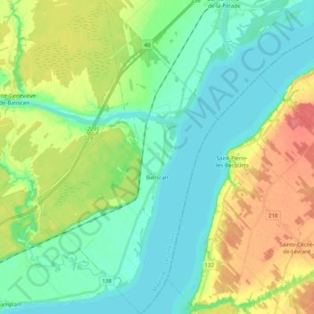
Name: Batiscan topographic map, elevation, terrain.
Location: Batiscan, Les Chenaux, Mauricie, Quebec, G0X 1A0, Canada (46.43704 -72.34946 46.57208 -72.21268)
Average elevation: 21 m
Minimum elevation: 0 m
Maximum elevation: 63 m
Other topographic maps
Click on a map to view its topography, its elevation and its terrain.
Notre-Dame-du-Mont-Carmel
Canada > Quebec > Les Chenaux
Notre-Dame-du-Mont-Carmel, Les Chenaux, Mauricie, Quebec, Canada
Average elevation: 98 m
Saint-Narcisse
Canada > Quebec > Les Chenaux > Saint-Narcisse
Saint-Narcisse, Les Chenaux, Mauricie, Quebec, G0X 2Y0, Canada
Average elevation: 105 m