
International Falls topographic map
Interactive map
Click on the map to display elevation.
About this map
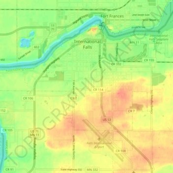
Name: International Falls topographic map, elevation, terrain.
Average elevation: 347 m
Minimum elevation: 322 m
Maximum elevation: 368 m
Other topographic maps
Click on a map to view its topography, its elevation and its terrain.
Rainy River
United States > Minnesota > Koochiching County
Rainy River, Koochiching County, Minnesota, 56629, United States
Average elevation: 341 m
Silverdale
United States > Minnesota > Koochiching County
Silverdale, Koochiching County, Minnesota, United States
Average elevation: 396 m
Rauch
United States > Minnesota > Koochiching County
Rauch, Koochiching County, Minnesota, United States
Average elevation: 388 m