
Clarendon topographic map
Interactive map
Click on the map to display elevation.
About this map
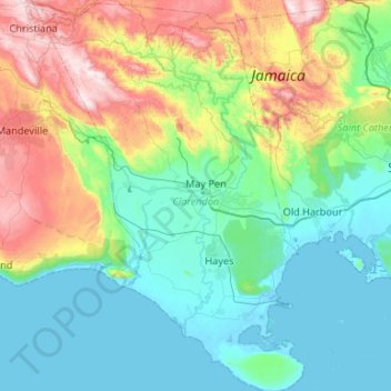
Name: Clarendon topographic map, elevation, terrain.
Location: Clarendon, Middlesex County, JMACN03, Jamaica (17.70556 -77.49417 18.20980 -77.12499)
Average elevation: 239 m
Minimum elevation: -4 m
Maximum elevation: 973 m
Other topographic maps
Click on a map to view its topography, its elevation and its terrain.
Stokesfield
Jamaica > Saint Thomas > Port Morant
Stokesfield, Port Morant, Saint Thomas, Surrey County, Jamaica
Average elevation: 41 m
German Town
Jamaica > Trelawny > Ulster Spring
German Town, Ulster Spring, Trelawny, Cornwall County, Jamaica
Average elevation: 505 m
Bogue Village
Bogue Village, Saint James, Cornwall County, Jamaica
Average elevation: 69 m
Cape Clear
Cape Clear, Saint Mary, Middlesex County, Jamaica
Average elevation: 167 m
Kingston and Saint Andrew Corporation
Kingston and Saint Andrew Corporation, Surrey County, Jamaica
Average elevation: 434 m
Salt Spring
Jamaica > Saint James > Salt Spring
Salt Spring, Saint James, Cornwall County, Jamaica
Average elevation: 195 m
Kingston
Jamaica > Kingston and Saint Andrew Corporation
Kingston, Kingston and Saint Andrew Corporation, Surrey County, Jamaica
Average elevation: 247 m
Dunrobin
Dunrobin, Saint Thomas, Surrey County, Jamaica
Average elevation: 539 m
Blue Mountain Peak
Blue Mountain Peak, Portland, Surrey County, Jamaica
Average elevation: 1,808 m
Mandeville
Mandeville, Manchester, Middlesex County, Jamaica
Average elevation: 615 m