
Raisin River topographic map
Interactive map
Click on the map to display elevation.
About this map
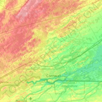
Name: Raisin River topographic map, elevation, terrain.
Average elevation: 73 m
Minimum elevation: 36 m
Maximum elevation: 124 m
Other topographic maps
Click on a map to view its topography, its elevation and its terrain.
Glen Walter
Canada > Ontario > South Glengarry > Glen Walter
Glen Walter, South Glengarry, Stormont, Dundas and Glengarry Counties, Eastern Ontario, Ontario, K6H 5R5, Canada
Average elevation: 50 m
Cooper Marsh Conservation Area
Canada > Ontario > South Glengarry
Cooper Marsh Conservation Area, Muskrat Motor, South Glengarry, Stormont, Dundas and Glengarry Counties, Eastern Ontario, Ontario, K0C 1N0, Canada
Average elevation: 48 m
Rivière Beaudette
Canada > Ontario > South Glengarry
Rivière Beaudette, South Glengarry, Stormont, Dundas and Glengarry Counties, Ontario, K0C 1L0, Canada
Average elevation: 69 m