
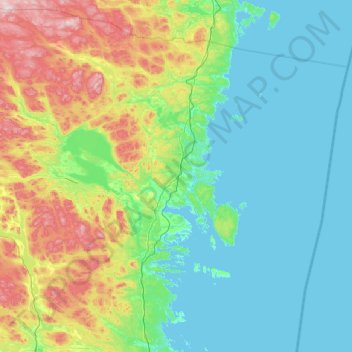
Hudiksvall topographic map
Interactive map
Click on the map to display elevation.
About this map
Name: Hudiksvall topographic map, elevation, terrain.
Average elevation: 98 m
Minimum elevation: -1 m
Maximum elevation: 535 m
Other topographic maps
Click on a map to view its topography, its elevation and its terrain.
Järvsö
Sweden > Gävleborg County > Järvsö
Järvsö, Ljusdals kommun, Gävleborg County, Region Norrland, 820 40, Sweden
Average elevation: 180 m
Hudiksvall
Sweden > Gävleborg County > Hudiksvall
Hudiksvall, Hudiksvalls kommun, Gävleborg County, Region Norrland, 82423, Sweden
Average elevation: 33 m
Gävle
Sweden > Gävleborg County > Gävle
Gävle, Gävle kommun, Gävleborg County, Region Norrland, 80130, Sweden
Average elevation: 39 m
Vallåsen
Vallåsen, Hudiksvall, Province Hälsingland, Gävleborg County, Region Norrland, Sweden
Average elevation: 226 m
Kölen
Kölen, Ljusdal, Province Hälsingland, Gävleborg County, Region Norrland, Sweden
Average elevation: 308 m
Ljusdal
Sweden > Gävleborg County > Ljusdal
Ljusdal, Province Hälsingland, Gävleborg County, Region Norrland, 82700, Sweden
Average elevation: 160 m
Limön
Sweden > Gävleborg County > Gävle
Limön, Gävle, Province Gästrikland, Gävleborg County, Region Norrland, Sweden
Average elevation: 1 m
Garpkölen
Garpkölen, Ljusdal, Province Hälsingland, Gävleborg County, Region Norrland, Sweden
Average elevation: 487 m
Söderåsen
Sweden > Gävleborg County > Söderåsen
Söderåsen, Nordanstig, Province Hälsingland, Gävleborg County, Region Norrland, Sweden
Average elevation: 124 m