
Sussex County topographic map
Interactive map
Click on the map to display elevation.
About this map
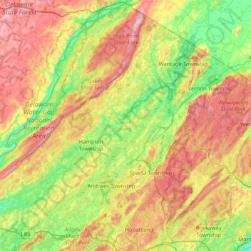
Name: Sussex County topographic map, elevation, terrain.
Location: Sussex County, New Jersey, United States (40.89914 -74.99193 41.35727 -74.36760)
Average elevation: 250 m
Minimum elevation: 67 m
Maximum elevation: 533 m
The Delaware River forms the western and northwestern boundary of Sussex County. This region is known as the Upper Delaware Valley and historically as the Minisink or Minisink Valley. Elevations in the regions along the river range from 300 to 500 feet.: p.3
Other topographic maps
Click on a map to view its topography, its elevation and its terrain.
Vernon Township
United States > New Jersey > Sussex County
Vernon Township, Sussex County, New Jersey, United States
Average elevation: 253 m
Warbasse
United States > New Jersey > Sussex County > Lafayette Township
Warbasse, Lafayette Township, Sussex County, New Jersey, 07848, United States
Average elevation: 186 m
Buffalo
United States > New Jersey > Sussex County > Wantage > Beemerville
Buffalo, Beemerville, Wantage, Sussex County, New Jersey, United States
Average elevation: 237 m