
Rabun County topographic map
Interactive map
Click on the map to display elevation.
About this map
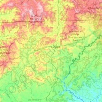
Name: Rabun County topographic map, elevation, terrain.
Location: Rabun County, Georgia, United States (34.71594 -83.66164 35.00068 -83.09834)
Average elevation: 687 m
Minimum elevation: 198 m
Maximum elevation: 1,650 m
The Eastern Continental Divide runs through the county, roughly from southwest to northeast, also representing a portion of the Tennessee Valley Divide. The county's eastern border with South Carolina is formed by the Chattooga River, the largest tributary of the Tugaloo River and then Savannah River (which forms the rest of the border of the two states). The north-central portion of Rabun County is in the watershed of the Little Tennessee River, which flows northward from Mountain City. The high elevation along the divide gives Rabun County the most snow of any in county in Georgia. This also gives it mild weather throughout the warmer months of the year, leading to the county's slogan, Where Spring Spends the Summer. Rabun County is the only county in Georgia with three state parks: Black Rock Mountain, Moccasin Creek, and Tallulah Gorge.
Other topographic maps
Click on a map to view its topography, its elevation and its terrain.
Chatham County
United States > Georgia > Chatham County
Chatham County, Georgia, United States
Average elevation: 3 m
Bonaire
United States > Georgia > Houston County
Bonaire, Houston County, Georgia, 31005, United States
Average elevation: 100 m
Helen
United States > Georgia > White County
Helen, White County, Georgia, 30545, United States
Average elevation: 488 m
Booth Lake
United States > Georgia > Wilkes County > Washington > Ravenwood Park
Booth Lake, Ravenwood Park, Washington, Wilkes County, Georgia, United States
Average elevation: 175 m
Fort Pulaski
United States > Georgia > Chatham County
Fort Pulaski, Fort Perimeter Trail, Chatham County, Georgia, 31328, United States
Average elevation: 1 m
Griffin Lake
United States > Georgia > Brooks County
Griffin Lake, Brooks County, Georgia, United States
Average elevation: 60 m
Rowland Lake
United States > Georgia > Jones County
Rowland Lake, Jones County, Georgia, United States
Average elevation: 175 m
Ponder Park
United States > Georgia > Tift County > Omega
Ponder Park, Omega, Tift County, Georgia, United States
Average elevation: 96 m
Hiawassee
United States > Georgia > Towns County
Hiawassee, Towns County, Georgia, United States
Average elevation: 620 m
Powder Springs
United States > Georgia > Cobb County
Powder Springs, Cobb County, Georgia, United States
Average elevation: 291 m
Brasstown Bald
United States > Georgia > Towns County
Brasstown Bald, Towns County, Georgia, United States
Average elevation: 1,161 m
Adel
United States > Georgia > Cook County
Adel, Cook County, Georgia, 31620, United States
Average elevation: 72 m
Cherokee Hills
United States > Georgia > Coffee County
Cherokee Hills, Coffee County, Georgia, United States
Average elevation: 70 m
Lake City
United States > Georgia > Clayton County
Lake City, Clayton County, Georgia, United States
Average elevation: 287 m
Whitfield County
Whitfield County, Georgia, United States
Average elevation: 258 m
Forbes Lake
United States > Georgia > Macon County
Forbes Lake, Macon County, Georgia, United States
Average elevation: 126 m
Leesburg
United States > Georgia > Lee County
Leesburg, Lee County, Georgia, United States
Average elevation: 76 m
Snodgrass Hill
United States > Georgia > Walker County > Fort Oglethorpe
Snodgrass Hill, Fort Oglethorpe, Walker County, Georgia, 30741, United States
Average elevation: 250 m
Moon River
United States > Georgia > Chatham County > Burnside View
Moon River, Burnside View, Chatham County, Georgia, 31411, United States
Average elevation: 2 m
Rossville
United States > Georgia > Walker County
Rossville, Walker County, Georgia, United States
Average elevation: 251 m
Lake Seminole
United States > Georgia > Seminole County > Chattahoochee
Lake Seminole, Chattahoochee, Seminole County, Georgia, United States
Average elevation: 32 m
Baxley
United States > Georgia > Appling County
Baxley, Appling County, Georgia, 31515, United States
Average elevation: 61 m
Bainbridge
United States > Georgia > Decatur County
Bainbridge, Decatur County, Georgia, United States
Average elevation: 37 m
Shenandoah Woods
United States > Georgia > Columbia County
Shenandoah Woods, Columbia County, Georgia, 30907, United States
Average elevation: 97 m
Hiram
United States > Georgia > Paulding County
Hiram, Paulding County, Georgia, United States
Average elevation: 306 m
Roswell
United States > Georgia > Fulton County
Roswell, Fulton County, Georgia, United States
Average elevation: 316 m
Lawrenceville
United States > Georgia > Gwinnett County
Lawrenceville, Gwinnett County, Georgia, United States
Average elevation: 312 m
High Hill Lake
United States > Georgia > Glynn County
High Hill Lake, Glynn County, Georgia, 31525, United States
Average elevation: 7 m
Newnan
United States > Georgia > Coweta County
Newnan, Coweta County, Georgia, 30263, United States
Average elevation: 272 m
Crowe Lake
United States > Georgia > Gwinnett County
Crowe Lake, Gwinnett County, Georgia, United States
Average elevation: 349 m
Tybee Island
United States > Georgia > Chatham County
Tybee Island, Chatham County, Georgia, 31328, United States
Average elevation: 1 m
Johns Creek
United States > Georgia > Fulton County > Johns Creek
Johns Creek, Fulton County, Georgia, 30097, United States
Average elevation: 305 m
Atlanta
United States > Georgia > Fulton County
Atlanta, Fulton County, Georgia, 30303, United States
Average elevation: 285 m
Peachtree City
United States > Georgia > Fayette County
Peachtree City, Fayette County, Georgia, 30269, United States
Average elevation: 263 m
Milton
United States > Georgia > Fulton County
Milton, Fulton County, Georgia, 30004, United States
Average elevation: 330 m
Colquitt County
Colquitt County, Georgia, United States
Average elevation: 85 m
Bonair
United States > Georgia > Richmond County > Augusta
Bonair, Augusta, Richmond County, Georgia, 30990, United States
Average elevation: 84 m