
Coulonge River topographic map
Interactive map
Click on the map to display elevation.
About this map
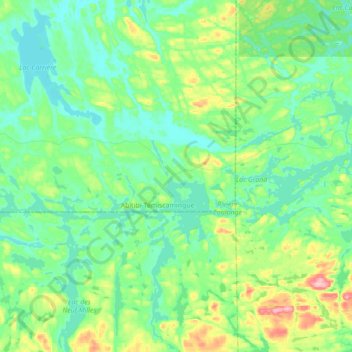
Name: Coulonge River topographic map, elevation, terrain.
Average elevation: 378 m
Minimum elevation: 344 m
Maximum elevation: 496 m
Other topographic maps
Click on a map to view its topography, its elevation and its terrain.
Lac Grand
Canada > Quebec > Réservoir-Dozois
Lac Grand, R0765, Réservoir-Dozois, La Vallée-de-la-Gatineau, Outaouais, Quebec, Canada
Average elevation: 362 m