
Ko Pha Ngan topographic map
Interactive map
Click on the map to display elevation.
About this map
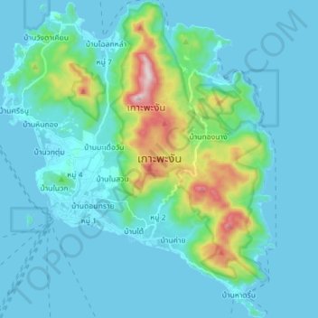
Name: Ko Pha Ngan topographic map, elevation, terrain.
Location: Ko Pha Ngan, Surat Thani Province, Thailand (9.66567 99.96074 9.80402 100.08177)
Average elevation: 84 m
Minimum elevation: 0 m
Maximum elevation: 602 m
Due to its topography, the population hugs the coastline. The mountainous interior is generally inaccessible. More than half the island designated as national park and Ko Pha-ngan has more than 80 km2 (31 sq mi) of relatively unspoiled rain forest with diverse flora and fauna. It is also considered a spiritual place, with numerous Buddhist temples around the island and a thriving spa, retreat, and meditation industry.
Other topographic maps
Click on a map to view its topography, its elevation and its terrain.
Ko Samui
Thailand > Surat Thani Province
Ko Samui, Surat Thani Province, Thailand
Average elevation: 75 m
Ban Na San
Thailand > Surat Thani Province > Ban Na San
Ban Na San, Surat Thani Province, Thailand
Average elevation: 53 m
Surat Thani Province
Thailand > Surat Thani Province
Surat Thani Province, Thailand
Average elevation: 27 m
Moo 4
Thailand > Surat Thani Province > Moo 4
Moo 4, Surat Thani Province, 84280, Thailand
Average elevation: 22 m