
Courchevel topographic map
Interactive map
Click on the map to display elevation.
About this map
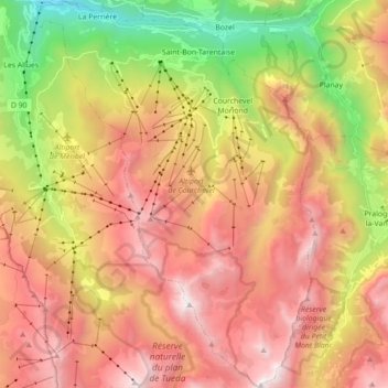
Name: Courchevel topographic map, elevation, terrain.
Average elevation: 1,903 m
Minimum elevation: 603 m
Maximum elevation: 3,149 m
Other topographic maps
Click on a map to view its topography, its elevation and its terrain.
Vanoise massif
France > Auvergne-Rhône-Alpes > Courchevel
Vanoise massif, Courchevel, Albertville, Savoy, Auvergne-Rhône-Alpes, Metropolitan France, France
Average elevation: 1,989 m