
At-Bashi River topographic map
Interactive map
Click on the map to display elevation.
About this map
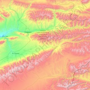
Name: At-Bashi River topographic map, elevation, terrain.
Location: At-Bashi River, Naryn Region, 722620, Kyrgyzstan (41.15120 75.59785 41.38518 77.03596)
Average elevation: 3,154 m
Minimum elevation: 1,824 m
Maximum elevation: 4,809 m
Other topographic maps
Click on a map to view its topography, its elevation and its terrain.
At-Bashy
Kyrgyzstan > Naryn Region > At-Bashy District
At-Bashy, At-Bashy District, Naryn Region, 722620, Kyrgyzstan
Average elevation: 2,070 m
Kochkor River
Kochkor River, Naryn Region, Kyrgyzstan
Average elevation: 1,888 m
Sarychat glacier
Sarychat glacier, Naryn Region, Kyrgyzstan
Average elevation: 4,217 m