
Chesterton topographic map
Interactive map
Click on the map to display elevation.
About this map
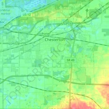
Name: Chesterton topographic map, elevation, terrain.
Location: Chesterton, Porter County, Indiana, 46304, United States (41.55020 -87.12480 41.64485 -87.01881)
Average elevation: 200 m
Minimum elevation: 181 m
Maximum elevation: 250 m
Other topographic maps
Click on a map to view its topography, its elevation and its terrain.
Valparaiso
United States > Indiana > Porter County
Valparaiso, Porter County, Indiana, United States
Average elevation: 235 m
Portage
United States > Indiana > Porter County
Portage, Porter County, Indiana, United States
Average elevation: 190 m
Burns Harbor
United States > Indiana > Porter County
Burns Harbor, Porter County, Indiana, United States
Average elevation: 189 m
Indiana Dunes National Park
United States > Indiana > Porter County > Portage
Indiana Dunes National Park, Portage, Porter County, Indiana, 46403, United States
Average elevation: 188 m
Ogden Dunes
United States > Indiana > Porter County
Ogden Dunes, Porter County, Indiana, United States
Average elevation: 184 m
Kouts
United States > Indiana > Porter County
Kouts, Porter County, Indiana, 46347, United States
Average elevation: 208 m
Chesterton
United States > Indiana > Porter County > Chesterton
Chesterton, Porter County, Indiana, 46304, United States
Average elevation: 197 m
Beverly Shores
United States > Indiana > Porter County > Beverly Shores > Beverly Shores
Beverly Shores, Porter County, Indiana, 46301, United States
Average elevation: 182 m
Hebron
United States > Indiana > Porter County
Hebron, Porter County, Indiana, 46341, United States
Average elevation: 213 m