
Minnesota topographic map
Interactive map
Click on the map to display elevation.
About this map
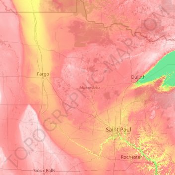
Name: Minnesota topographic map, elevation, terrain.
Location: Minnesota, United States (43.49943 -97.23926 49.38447 -89.48339)
Average elevation: 378 m
Minimum elevation: 176 m
Maximum elevation: 678 m
The state's high point is Eagle Mountain at 2,301 feet (701 m), which is only 13 miles (21 km) away from the low point of 601 feet (183 m) at the shore of Lake Superior. Notwithstanding dramatic local differences in elevation, much of the state is a gently rolling peneplain.
Other topographic maps
Click on a map to view its topography, its elevation and its terrain.
USA
United States > Texas > Tarrant County > Arlington
USA, Arlington, Tarrant County, Texas, 76011, United States
Average elevation: 170 m
Colorado Springs
United States > Colorado > El Paso County
Colorado Springs, El Paso County, Colorado, United States
Average elevation: 2,252 m
Phoenix
United States > Arizona > Maricopa County
Phoenix, Maricopa County, Arizona, United States
Average elevation: 481 m
Orange County
Orange County, California, United States
Average elevation: 112 m
Orlando
United States > Florida > Orange County
Orlando, Orange County, Florida, United States
Average elevation: 30 m
Lubbock
United States > Texas > Lubbock County
Lubbock, Lubbock County, Texas, United States
Average elevation: 983 m
Bucks County
Bucks County, Pennsylvania, United States
Average elevation: 98 m
Galveston
United States > Texas > Galveston County
Galveston, Galveston County, Texas, United States
Average elevation: 1 m
Huntington Beach
United States > California > Orange County
Huntington Beach, Orange County, California, United States
Average elevation: 7 m
Westchester County
Westchester County, New York, United States
Average elevation: 95 m
Saint George
United States > Utah > Washington County
Saint George, Washington County, Utah, United States
Average elevation: 929 m
Palm Desert
United States > California > Riverside County
Palm Desert, Riverside County, CAL Fire Southern Region, California, United States
Average elevation: 178 m
Hernando County
Hernando County, Florida, United States
Average elevation: 18 m
Sioux Falls
United States > South Dakota > Minnehaha County
Sioux Falls, Sioux Falls Township, Minnehaha County, South Dakota, United States
Average elevation: 445 m
Las Cruces
United States > New Mexico > Doña Ana County
Las Cruces, Doña Ana County, New Mexico, United States
Average elevation: 1,297 m
Okaloosa County
Okaloosa County, Florida, United States
Average elevation: 37 m
Ontario
United States > Oregon > Malheur County > Ontario
Ontario, Malheur County, Oregon, 97914, United States
Average elevation: 660 m
Calumet
United States > Oklahoma > Canadian County
Calumet, Canadian County, Oklahoma, United States
Average elevation: 421 m
Coos Bay
United States > Oregon > Coos County
Coos Bay, Coos County, Oregon, 97420, United States
Average elevation: 30 m
Rapid City
United States > South Dakota > Pennington County
Rapid City, Pennington County, South Dakota, United States
Average elevation: 1,067 m
Santa Monica
Santa Monica, California, United States
Average elevation: 30 m
Pearl Harbor
United States > Hawaii > Honolulu County > Pearl City
Pearl Harbor, Pearl City, Honolulu County, Hawaii, United States
Average elevation: 22 m
Overland Park
United States > Kansas > Johnson County
Overland Park, Johnson County, Kansas, United States
Average elevation: 300 m
Long Beach
United States > California > Los Angeles County
Long Beach, Los Angeles County, California, United States
Average elevation: 12 m
Lake Charles
United States > Louisiana > Calcasieu Parish
Lake Charles, Calcasieu Parish, Louisiana, United States
Average elevation: 5 m
Leonia
United States > New Jersey > Bergen County
Leonia, Bergen County, New Jersey, 07605, United States
Average elevation: 35 m
Merritt Island
United States > Florida > Brevard County > Cocoa
Merritt Island, Cocoa, Brevard County, Florida, United States
Average elevation: 4 m
Palmdale
United States > California > Los Angeles County
Palmdale, Los Angeles County, California, United States
Average elevation: 898 m
Hayward
United States > California > Alameda County
Hayward, Alameda County, California, United States
Average elevation: 77 m
Laguna Beach
United States > California > Orange County
Laguna Beach, Orange County, California, United States
Average elevation: 62 m
Yellowstone National Park
Yellowstone National Park, Wyoming, United States
Average elevation: 2,450 m
Redding
United States > California > Shasta County
Redding, Shasta County, CAL Fire Northern Region, California, United States
Average elevation: 240 m
Tacoma
United States > Washington > Pierce County
Tacoma, Pierce County, Washington, United States
Average elevation: 67 m
Hoboken
United States > New Jersey > Hudson County
Hoboken, Hudson County, New Jersey, 07030, United States
Average elevation: 14 m
Seattle
United States > Washington > King County
Seattle, King County, Washington, United States
Average elevation: 40 m
Las Vegas
United States > New Mexico > San Miguel County
Las Vegas, San Miguel County, New Mexico, 87701, United States
Average elevation: 1,994 m
Pitsburg
United States > Ohio > Darke County
Pitsburg, Darke County, Ohio, 45358, United States
Average elevation: 312 m
Bismarck
United States > North Dakota > Burleigh County
Bismarck, Burleigh County, North Dakota, United States
Average elevation: 523 m
Baton Rouge
United States > Louisiana > East Baton Rouge Parish
Baton Rouge, East Baton Rouge Parish, Louisiana, United States
Average elevation: 13 m
Mountain View
United States > California > Santa Clara County
Mountain View, Santa Clara County, California, United States
Average elevation: 25 m