
Maple Lake topographic map
Interactive map
Click on the map to display elevation.
About this map
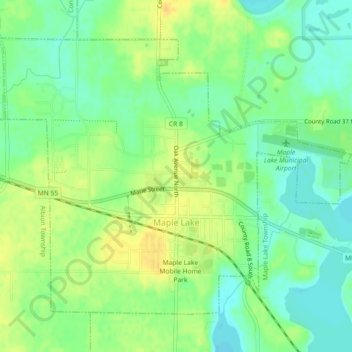
Name: Maple Lake topographic map, elevation, terrain.
Location: Maple Lake, Wright County, Minnesota, United States (45.22078 -94.02465 45.24582 -93.97937)
Average elevation: 314 m
Minimum elevation: 301 m
Maximum elevation: 329 m
Other topographic maps
Click on a map to view its topography, its elevation and its terrain.
Howard Lake
United States > Minnesota > Wright County
Howard Lake, Wright County, Minnesota, 55349, United States
Average elevation: 312 m
Maple Lake
United States > Minnesota > Wright County > Maple Lake > Maple Lake
Maple Lake, Wright County, Minnesota, 55358, United States
Average elevation: 314 m
Annandale
United States > Minnesota > Wright County
Annandale, Wright County, Minnesota, United States
Average elevation: 323 m