
Fermont topographic map
Interactive map
Click on the map to display elevation.
About this map
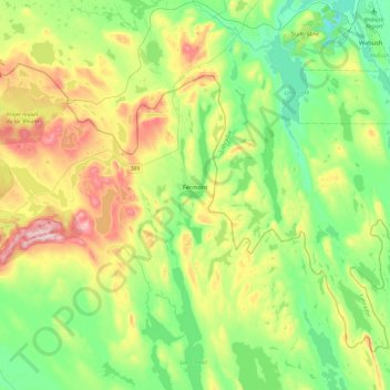
Name: Fermont topographic map, elevation, terrain.
Average elevation: 632 m
Minimum elevation: 501 m
Maximum elevation: 904 m
Other topographic maps
Click on a map to view its topography, its elevation and its terrain.
Rivière Moisie
Canada > Quebec > Caniapiscau (MRC) > Rivière-Mouchalagane
Rivière Moisie, Rivière-Mouchalagane, Caniapiscau (MRC), Côte-Nord, Quebec, Canada
Average elevation: 507 m
Schefferville
Canada > Quebec > Caniapiscau (MRC)
Schefferville, Caniapiscau (MRC), Côte-Nord, Quebec, G0G 2T0, Canada
Average elevation: 537 m