
Windermere topographic map
Interactive map
Click on the map to display elevation.
About this map
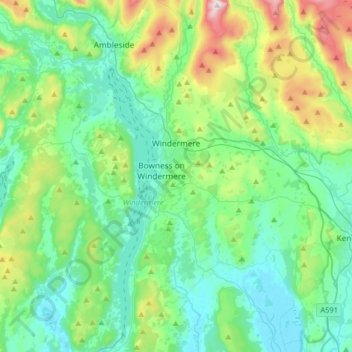
Name: Windermere topographic map, elevation, terrain.
Average elevation: 161 m
Minimum elevation: 2 m
Maximum elevation: 705 m
Other topographic maps
Click on a map to view its topography, its elevation and its terrain.
Coniston Water
United Kingdom > England > South Lakeland > Coniston > Dixon Ground
Coniston Water, B5285, Dixon Ground, Coniston, South Lakeland, Cumbria, North West England, England, LA21 8AJ, United Kingdom
Average elevation: 186 m
The Howe
United Kingdom > England > South Lakeland
The Howe, South Lakeland, Cumbria, North West England, England, LA23 1NY, United Kingdom
Average elevation: 225 m
High Fall
United Kingdom > England > South Lakeland
High Fall, South Lakeland, Cumbria, North West England, England, LA22 9LX, United Kingdom
Average elevation: 239 m
Heron Island
United Kingdom > England > South Lakeland
Heron Island, South Lakeland, Cumbria, North West England, England, United Kingdom
Average elevation: 173 m