
Torsby kommun topographic map
Interactive map
Click on the map to display elevation.
About this map
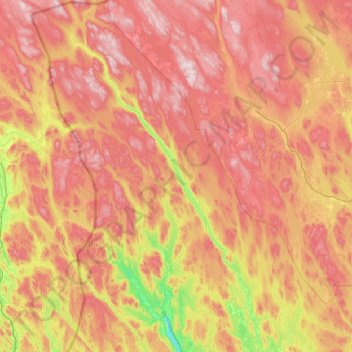
Name: Torsby kommun topographic map, elevation, terrain.
Location: Torsby kommun, Värmland County, Region Svealand, Sweden (60.03315 12.22399 61.05600 13.62195)
Average elevation: 354 m
Minimum elevation: 57 m
Maximum elevation: 748 m
Other topographic maps
Click on a map to view its topography, its elevation and its terrain.
Hagfors
Sweden > Värmland County > Hagfors
Hagfors, Värmland County, Region Svealand, 683 30, Sweden
Average elevation: 203 m
Skoghall
Sweden > Värmland County > Skoghall
Skoghall, Hammarö kommun, Värmland County, Region Svealand, 66334, Sweden
Average elevation: 48 m
Åkershus
Sweden > Värmland County > Åkershus
Åkershus, Säffle kommun, Värmland County, Region Svealand, Sweden
Average elevation: 47 m
Mansån
Mansån, Sunne kommun, Värmland County, Region Svealand, Sweden
Average elevation: 271 m
Årjängs kommun
Årjängs kommun, Värmland County, Region Svealand, Sweden
Average elevation: 176 m
Dalby distrikt
Sweden > Värmland County > Sysslebäck
Dalby distrikt, Sysslebäck, Torsby, Värmland County, Region Svealand, Sweden
Average elevation: 315 m
Hagfors
Hagfors, Värmland County, Region Svealand, Sweden
Average elevation: 256 m
Vänern
Sweden > Värmland County > Åkershus
Vänern, Åkershus, Säffle, Värmland County, Region Svealand, Sweden
Average elevation: 78 m