
Ivanovo topographic map
Interactive map
Click on the map to display elevation.
About this map
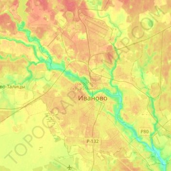
Name: Ivanovo topographic map, elevation, terrain.
Location: Ivanovo, Ivanovo Oblast, Central Federal District, Russia (56.94645 40.86788 57.07073 41.12663)
Average elevation: 128 m
Minimum elevation: 102 m
Maximum elevation: 149 m
Other topographic maps
Click on a map to view its topography, its elevation and its terrain.
Троицкая
Russia > Ivanovo Oblast > Yuryevetsky District > Yuryevets
Троицкая, Yuryevets, Yuryevetsky District, Ivanovo Oblast, Central Federal District, 155453, Russia
Average elevation: 110 m