
Frontier County topographic map
Interactive map
Click on the map to display elevation.
About this map
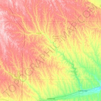
Name: Frontier County topographic map, elevation, terrain.
Location: Frontier County, Nebraska, United States of America (40.34876 -100.78350 40.70200 -99.98161)
Average elevation: 815 m
Minimum elevation: 673 m
Maximum elevation: 962 m
Other topographic maps
Click on a map to view its topography, its elevation and its terrain.
Kearney
United States of America > Nebraska > Kearney
Kearney, Buffalo County, Nebraska, United States of America
Average elevation: 662 m
Gretna
United States of America > Nebraska > Gretna
Gretna, Sarpy County, Nebraska, 68028, United States of America
Average elevation: 377 m
Conestoga Lake
United States of America > Nebraska > Lincoln > Emerald
Conestoga Lake, Southwest 98th Street, Emerald, Lincoln, Lancaster County, Nebraska, 68532, United States of America
Average elevation: 385 m
Mumper
United States of America > Nebraska > Mumper
Mumper, Garden County, Nebraska, United States of America
Average elevation: 1,174 m
Maplewood Estates MHP
United States of America > Nebraska > Omaha > Maplewood Estates MHP
Maplewood Estates MHP, Omaha, Douglas County, Nebraska, 68164, United States of America
Average elevation: 343 m
Walthill
United States of America > Nebraska > Walthill
Walthill, Thurston County, Nebraska, 68067, United States of America
Average elevation: 390 m