
Cali topographic map
Interactive map
Click on the map to display elevation.
About this map
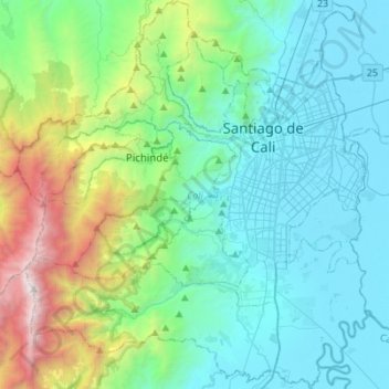
Name: Cali topographic map, elevation, terrain.
Location: Cali, Sur, Valle del Cauca, RAP Pacífico, Colombia (3.27341 -76.70694 3.54858 -76.45890)
Average elevation: 1,284 m
Minimum elevation: 941 m
Maximum elevation: 3,084 m
Under Köppen's climate classification, Cali features a dry-summer tropical savanna climate (Köppen climate classification: As). The Western Mountain Range rises from an average of 2,000 m (6,562 ft) above sea level in the northern part of the city to approximately 4,000 m (13,123 ft) to the south. Because of this variation in altitude, the weather in the northwest portion of the city is drier than in the southwest. The average annual precipitation varies between 900 to 1,800 mm (35 to 71 in) depending on the metropolitan zone for a citywide average of approximately 1,483 mm (58 in). Cali's average temperature is 24 °C (75 °F) with an average low temperature of 17.4 °C (63 °F) and a high of 30.5 °C (87 °F).
Other topographic maps
Click on a map to view its topography, its elevation and its terrain.
Cali
Colombia > Valle del Cauca > Cali
Cali, Sur, Valle del Cauca, RAP Pacífico, Colombia
Average elevation: 1,142 m
Buenaventura
Buenaventura, Valle del Cauca, RAP Pacífico, Colombia
Average elevation: 745 m
La Gran Colombia
Colombia > Valle del Cauca > Perímetro Urbano Santiago de Cali
La Gran Colombia, Comuna 11, Perímetro Urbano Santiago de Cali, Cali, Valle del Cauca, Colombia
Average elevation: 952 m