
Lora Bay topographic map
Interactive map
Click on the map to display elevation.
About this map
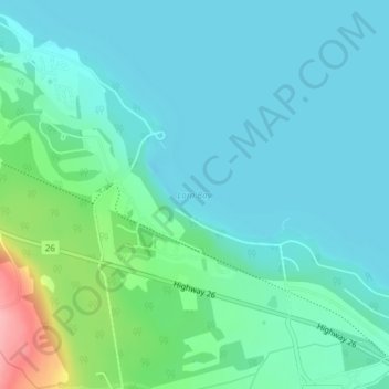
Name: Lora Bay topographic map, elevation, terrain.
Average elevation: 198 m
Minimum elevation: 172 m
Maximum elevation: 302 m
Other topographic maps
Click on a map to view its topography, its elevation and its terrain.
Ravenna
Canada > Ontario > The Blue Mountains > Ravenna
Ravenna, The Blue Mountains, Grey County, Southwestern Ontario, Ontario, Canada
Average elevation: 375 m
Craigleith Provincial Park
Canada > Ontario > The Blue Mountains
Craigleith Provincial Park, The Blue Mountains, Grey County, Ontario, Canada
Average elevation: 221 m
Pretty River Valley Provincial Park
Canada > Ontario > The Blue Mountains
Pretty River Valley Provincial Park, The Blue Mountains, Grey County, Ontario, Canada
Average elevation: 369 m