
Laghman Province topographic map
Interactive map
Click on the map to display elevation.
About this map
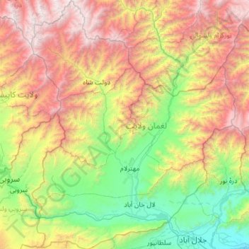
Name: Laghman Province topographic map, elevation, terrain.
Location: Laghman Province, Afghanistan (34.39482 69.80518 35.21933 70.63064)
Average elevation: 2,010 m
Minimum elevation: 503 m
Maximum elevation: 4,873 m
Other topographic maps
Click on a map to view its topography, its elevation and its terrain.
Mihtarlam
Afghanistan > Laghman Province
Mihtarlam, Laghman Province, Afghanistan
Average elevation: 1,368 m