
Bullhead City topographic map
Interactive map
Click on the map to display elevation.
About this map
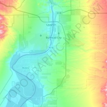
Name: Bullhead City topographic map, elevation, terrain.
Average elevation: 322 m
Minimum elevation: 144 m
Maximum elevation: 774 m
Hardyville Pioneer Cemetery, a small cemetery, now a historic landmark, is the most significant existing remnant of Hardyville at 35°7′16″N 114°35′17″W / 35.12111°N 114.58806°W / 35.12111; -114.58806. An unofficial historical marker for the town is in the parking lot across Highway 95 from the cemetery at 35°7′16″N 114°35′17″W / 35.12111°N 114.58806°W / 35.12111; -114.58806. The Hardyville Mill ruins appeared on a USGS Topographic map, at 35°7′14″N 114°34′47″W / 35.12056°N 114.57972°W / 35.12056; -114.57972.