
Al-Hasakah District topographic map
Interactive map
Click on the map to display elevation.
About this map
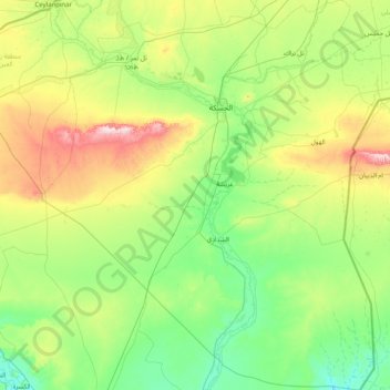
Name: Al-Hasakah District topographic map, elevation, terrain.
Location: Al-Hasakah District, Al-Hasaka Governorate, Syria (35.55309 40.00291 36.85724 41.38665)
Average elevation: 356 m
Minimum elevation: 201 m
Maximum elevation: 914 m
Other topographic maps
Click on a map to view its topography, its elevation and its terrain.
Ras Al-Ayn Subdistrict
Syria > Al-Hasaka Governorate > Ras al-Ayn > Ras-Al-Ayn
Ras Al-Ayn Subdistrict, Ras al-Ayn, Ras-Al-Ayn, Ras Al-Ayn District, Al-Hasaka Governorate, Syria
Average elevation: 368 m
Muhafazat al Hasakah
Muhafazat al Hasakah, Bir al-Helou al-Wardiya Subdistrict, Al-Hasakah District, Al-Hasaka Governorate, Syria
Average elevation: 447 m
Al-Hasakah
Syria > Al-Hasaka Governorate > Al-Hasakah
Al-Hasakah, Al-Hasakah Subdistrict, Al-Hasakah District, Al-Hasaka Governorate, Syria
Average elevation: 337 m